
The National Severe Storms Laboratory estimates that more than 800 tornadoes occur each year in the United States. They have been recorded in every state, as well as in many other countries. In the United States, tornadoes are particularly common in the Great Plains, from the Rocky Mountains to the Appalachians, and they most often form in the spring and early summer.
Why and how tornadoes form is still not well understood. Often they form from rotating thunderstorms called mesocyclones. These form when winds in the bottom layer of the atmosphere just above the ground are moving in a different direction, and at a different speed, than winds in the layer directly above. Where the two layers touch each other, the conflicting winds “pull apart” or “shove around” the air at the boundary, until sometimes the air starts to roll over itself. This initial rotating is like that of a pencil if you roll it across a table with the palm of your hand. Sometimes, again for reasons not fully understood, this spinning movement is turned vertically — as if you stood the spinning pencil up on its tip — and if this type of rotation develops in a thunderstorm it is a mesocyclone. Tornadoes then form in several different ways, none of them well understood, from the rotating mesocyclone as the spinning air tightens and speeds up in small, localized regions.
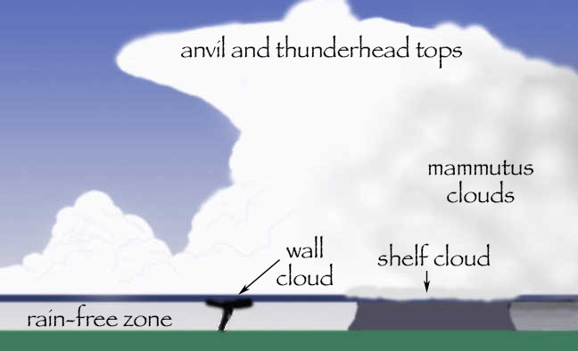
One thing that is thought to tip the horizontal rotation vertically is the rising hot air beneath the thunderstorm. Such an updraft fuels the storm’s power. Because of the updrafts, strong winds on the ground that are rushing toward a thunderstorm are one of the indicators that severe weather may be imminent. The sky is also usually very dark, the color of a bad bruise, and the clouds commonly have a sickly greenish cast.
Conditions that might spawn a tornado can be recognized long before things get that far, though, by anyone who studies the sky. Towering thunderheads are most likely to produce tornadoes. Heavy rain, hail, and lightning are usually associated with such storms. Tornadoes often form at the base of a wall cloud, which is a lowering of the underside of the thunderhead. Not all wall clouds produce tornadoes, but anyone who sees such signs — especially large hail — should pay close attention to local weather reports for storm watches and warnings.
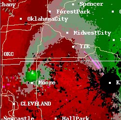
Thirty years ago, tornado warnings were issued when a spotter reported seeing a funnel touch the ground, and since rain and darkness often made it hard for spotters to see them, it was not uncommon for a tornado to suprise everyone in its initial path. Now Doppler radar is used to pinpoint tornado location and direction of travel with more reliability.

Adequate warning is important to the safety of people in a tornado’s path because of the destructive power they can have. NSSL’s Project VORTEX (Verification of Rotation in Tornadoes Experiment) reports that a tornado near the town of Friona, Texas on June 2, 1995 did the following damage: “A several-ton railroad boxcar that served as a storage building bounced through the cemetery, destroying monuments and gouging a two-foot deep hole through an asphalt drive into hard-packed soil. The boxcar traveled about 100 meters.” A little later, the same storm system spawned a tornado in Dimmitt, Texas that did damage described in the VORTEX report this way: “When the tornado crossed TX 86, it removed the pavement in a 10 meter wide swath over a length of approximately 100 meters. The [thin layer of] asphalt was thrown over 200 meters into the adjacent field. Power poles were snapped at the ground. Vehicles were totally destroyed, with reports of two truck trailers missing entirely.”
Not all tornadoes are that strong, but some are stronger. The Fujita scale estimates the power of a given tornado by assessing the kind of damage it has done to human-built structures. F-0 is the weakest rating, and F-5 the strongest. Estimated wind speeds within the funnel itself are based upon what would be necessary to cause the amount of damage seen, and also upon measurements taken by scientists doing research such as NSSL’s VORTEX2. Fortunately, most tornadoes are low-strength. Fewer than 2% of all tornadoes are F-4 or F-5 storms, but they take 80% of lives lost to tornadoes. Seven out of ten tornadoes are F-0 or F-1, and almost all the rest are F-2 and F-3. A newer Enhanced Fujita (EF) Scale is increasingly used to estimate a tornado’s power, with an EF-3 tornado packing windspeeds of between 136 and 165 miles per hour. Like the original F scale, the EF scale is calculated based on the Degree of Damage (DOD) to structures, which means that the power of tornadoes in open country without structures usually cannot be estimated. Most tornadoes can be survived by following National Weather Service guidelines to go into an innermost room on the ground floor of a structure.
What should you do if a tornado is nearby? At that moment, the safety of yourself and others in your household may depend on you making the right decision. What you do can even affect others in your community; motorists who blocked highways may have caused injuries and deaths in the 1998 Oklahoma City tornadoes, that could otherwise have been avoided.
Continue to Experiential Ways of Knowing and Learning About Tornadoes.
Return to Intellectual Ways of Learning and Knowing.
You may use the table below to explore the directions, their associated ways of knowing and learning, and an example of each type of learning as applied to understanding tornadoes.
People who provided invaluable advice, explanations, images, and editorial assistance to the creation of these pages in 2007, with our thanks.
- Chuck Doswell, NSSL
- Alan Moller, NWS
- Daphne Zaras, NSSL
- Mary Meacham, NSSL
- Kevin Kelleher, NSSL
Any errors that might still exist on these pages are solely the responsibility of Tapestry.