

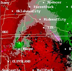
Doppler radar images of the F-5 tornado that swept away part of Moore, Oklahoma in the Oklahoma City area outbreak of May 3, 1999. The white line running north-south just east of Moore (to your right) is Interstate 35; the tornado is about to cross the intersection of I-35 and a smaller road at the Shields Overpass. The picture on the left is a reflectivity image. The one on the right is a velocity display. Both images are produced by Doppler radar.
The reflectivity image shows how hard the radio signal sent out is bounced back to the radar receiver. Rain and hail reflect this pulse more strongly than does “plain” air, so they make stronger echoes; the larger the droplet or hailstone, the more strongly the radar is echoed back to the receiver. Here, the white square is the region of highest reflectivity, and the orange on down through blue ones show progressively lower levels, and therefore less intense precipitation. In this particular case, the white areas probably show radar detection of actual debris within the tornado.
On the velocity display, the blocks of green color show areas where the wind is moving toward the radar equipment. The blocks of red show areas where the wind is moving away from the equipment. Notice that just north of Moore, there is an area where red and green touch each other directly, at the bottom of a long red “hook” that almost looks like a curved finger. The wind is spinning around a central vortex in this region where the red and green are in contact, rushing quickly away from the radar in the red places and toward it in the green ones. That is the velocity-display “signature” of a tornado, as it indicates the presence of rapidly rotating winds
You can learn more about Doppler radar, newer kinds of radar, and how they are used to find tornadoes at these sites:
Weather radar information at NSSL
Radar Meteorology: Online Remote Sensing Guide WW2010, University of Illinois
WW2010 University of Illinois page
Return to Intellectual Ways of Learning and Knowing About Tornadoes.